• home
  • Explore
    • county down
    • county antrim
    • county donegal
    • county derry
    • county kerry
    • county galway
    • county armagh
    • county clare
    • county mayo
    • rathlin island
    • county sligo
    • county wicklow
    • lisburn
    • county fermanagh
    • county tyrone
    • county cork
    • underexplored ireland
    • the world
  • Twelve Deals of Christmas
  • experience
  • about
  • Contact
Hibernia Landscapes
  • home
  • Explore
    • county down
    • county antrim
    • county donegal
    • county derry
    • county kerry
    • county galway
    • county armagh
    • county clare
    • county mayo
    • rathlin island
    • county sligo
    • county wicklow
    • lisburn
    • county fermanagh
    • county tyrone
    • county cork
    • underexplored ireland
    • the world
  • Twelve Deals of Christmas
  • experience
  • about
  • Contact

Donegal: When things go wrong

Surveying the Derryveagh mountains


When I upload my photographs or write blogs, I usually write about two things:

1) What it is I have photographed, what are the stories behind the place? Its name. Its history and its significance; as well as
2) My experiences of photographing the subject.  Usually in landscape photography there is an 'experience' to go hand-in-hand with every photograph.  It provides perhaps too much sentimental attachment to some photographs which perhaps aren't so good, and not enough to other photographs which are good but were maybe too 'easy' to get.

However, with this blog, whilst I'll touch on the above I want to discuss the practical sides of the photography itself.  What can go wrong, what I put in my bag, what lenses I have, what filters I use.  How I planned the trip in terms of fitting in locations.  And of course, how I decided to compose each shot at the time and my post-processing as well as some self-critique.  It's something I get a lot of emails about and hopefully is something a bit different from my usual posts.

THE PLAN

If i'm honest, I love planning for photographs. And I think a large part of this is a bit of a geeky fascination with maps.  This photo was taken in December, on those days between Christmas and New Year's that we always have to find ways to fill!  The importance of planning in landscape photography cannot be understated.  Sure, the best shots are often those 'unplanned' ones, and plans often go wrong (as you'll see), but there's usually a good reason that you're in the right place at the right time.

Talking of maps...

I had 4 detailed Donegal maps (Ordnance Survey Ireland - Discovery Series 1, 2, 6 and 10).  These four cover basically all of Donegal other than parts of the southeast and Inishowen both of which I didn't plan to visit on this trip.  Inishowen is fantastic, but I've visited there quite recently.

I also had a Sperrins Activity Map (by Ordnance Survey) as I planned to go up through the Sperrins on my way to Donegal.

My other map was just a plain old simple Road Atlas of Ireland.  

In planning for this trip I also used a fantastic book called 'Donegal, Sligo and Leitrim - A Walking Guide' by Adrian Hendroff.  This was because between the 'golden' hours of sunrise and sunset I planned to hike the Derryveagh mountains and to the summit of Slieve League, some of the highest sea cliffs in Europe.  I'd recommend this book to all interested in hiking in the north west.

I used the fantastic app that I have mentioned before 'The Photographer's Ephemeris' to plan which photo would work best at which time of day (and time of year).  If you have a smart phone and don't already have this app, download it now!

I had one more book and that was a nice blank notebook. So what did I write down? Here is a transcript (if I can read my own scribbles!)

Donegal Trip 2-3rd March

2nd March

Alarm 4.30am - Breakfast
Leave Lisburn 5am
7.15am sunrise - Beaghmore Stone Circles
8.15-8.45am - Gortin Lakes morning light
9am - Breakfast in Gortin village
11am - Arrive at Errigal mountain. Climb.
2.30pm - Quick lunch if time
3.30pm - Get to Murder Hole beach, Rosguill. afternoon light
4.30pm - drive to Lough salt
5pm - Climb Lough Salt mountain
Sunset 6.09pm - from Lough salt mountain summit
Go to hotel.
8pm - Liverpool v Man City

I then turn the page to my equally optimistic 3rd March plans....

3rd March

7.19am - Sunrise Dunlewy Lake (reflections)
Poisoned Glen - early morning light
Go for a fry at hotel and check out
11.30am - Arrive Teelin to climb Slieve League via One Man's Pass
4pm - Finish hike
Kilclooney Dolmen if have time
Crohy Head Sea arch sunset - 6.15pm.
Dinner and go home.

Now, looking back I don't think the plan was impossible, but it was as I say very optimistic even by my standards and needed all conditions to be perfect, which of course in early March is rare, and the roads to have no roadworks or tractors slowing me down between locations....  
Also before I left I had to scrap the sunset plans at Crohy Head on the Thursday... this was nothing to do with Julie's gym class!  So consider the updated plan to end at 'Finish hike'.

Anyway, that was the planning done.  

Now, it is the night before and it is time to pack my bag and take another look at the all-important weather for the days ahead. So what to put in my bag?

View fullsize IMG_8383.JPG
View fullsize IMG_8386.JPG
View fullsize IMG_8387.JPG
View fullsize IMG_8388.JPG
View fullsize IMG_8389.JPG

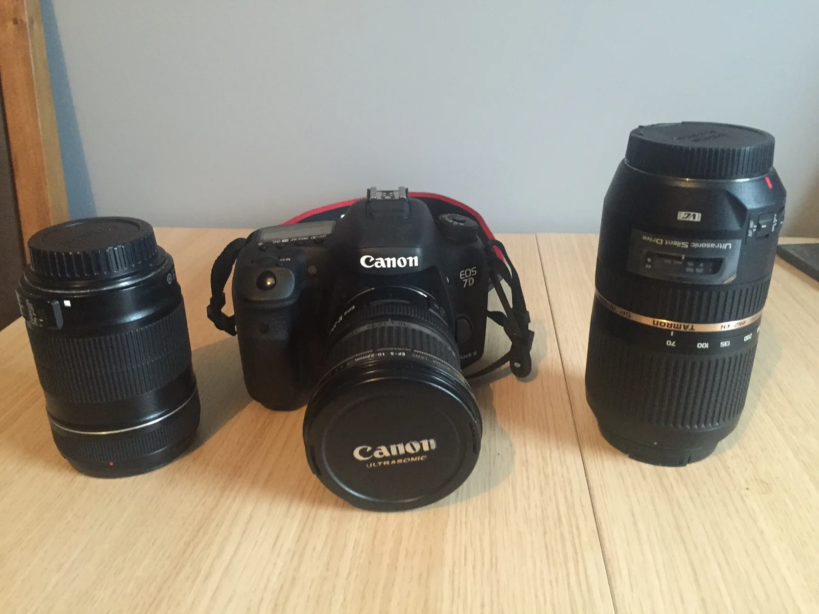
I have Lowepro 350 backpack that i find fantastic with its dedicated internal camera unit for the lenses and camera body itself with further compartments for my cleaning equipment, filters and then non-camera items such as my trusty gloves and beanie hat. Oh and a nice section for maps!  It's also really comfortable on your back and I happily take it hiking.

My camera is a Canon 7D Mark II.  I got it in July 2015 for my 30th birthday and I really enjoy it as it is a decent upgrade on my previous 550D.  I have 3 lenses:

  1. Canon EF-S f3.5 10-22mm - My wide angle.  My default lens if you like.  80% of my photos are probably taken with this.  It used to be 99%;
  2. Canon EF-S f3.5 18-135mm - My first ever lens.  A bit battle-worn but very versatile in range and I still use it sometimes.
  3. Canon EF-S f4.0 70-300mm - My zoom lens.  My newest lens also.  I got this at Christmas as I wanted to challenge myself to get different types of photos.  It's useful up in the mountains and to pick out details in the landscape.  A recent upload of mine you may have seen 'The Winding Road, Glens of Antrim' was taken with this lens and is the kind of shot I was thinking of. 

I have 3 filters, though 2 of them are just different sizes of the same filter (for different lenses).  These two are both 10-stop ND filters which basically allow me to get long exposures (to achieve movement of clouds, smoothing water etc) by letting less light into the camera.  The other filter is a polariser filter, which like the sunglasses, helps to reduce glare.

So, now the bag is packed.  I check the weather again.  What’s that? Snow? Storm Jake? Oh, this isn’t going to be as easy as I had planned!  

If you remember the list from above, that was the plan, this is the reality….

THE REALITY - DAY ONE!

4.30am and my alarm goes off.  I don’t turn it off in my sleep so the morning can be considered a success.  I look outside my window to check for ice and snow. Neither! The forecast said heavy snow in Lisburn from 4am…. I decide this is a sign to get on the road and get as far as I can before the snow starts.  My destination was still Beaghmore Stone Circles in the Sperrin mountains.  There’s bound to be bad roads to come.  

A traditional bowl of Jordan’s Strawberry Crisp and I’m on my way.  However, I wasn’t even out to the main road from my house when the snow started. And the forecast was correct. It was heavy!

By the time I made it to the motorway there were a few inches of fresh snow and the blizzard showed no signs of abating.  The motorway was more dangerous than I had expected it to be.  I was the first on the road and it is dark, there are no lights on the motorway and the blizzards made visibility poor. It was 5am and it was heavily snowing, why would anyone else be here?!! I began to question what I was doing.  I was knackered as it was.  Why couldn’t I just take the lie in? This was stupid.  Ah well, I’m up now.  A snowy sunrise could be great I tell myself, and anyway, I’m on my way to Donegal.  

By the time I get to Dungannon and leave the motorway I feel a bit better.  There are street lights here and other cars are starting to appear for work! The heavy snow stops but cloud is everywhere to be seen.  I decide to check my phone for the latest satellite pictures of the snow to see if it’s likely to be dry at sunrise. Oh…no phone. Did it fall out of my pocket? Please let it just have fallen out of my pocket? No sign of it! I ask 3 people at a filling station if they have a mobile phone I could use (to phone my own to see if it’s under the seat).  No-one in Dungannon has mobile phones it seems.  No, more likely no-one trusts a dishevelled looking man at 6.45am at a filling station asking to use their mobiles.  Eventually an ambulance driver loans me his phone, but no buzzing,  no ringing, that's it.  It’s at home!!

This is not good.  I need my phone to keep in touch with my family at home.  It’s 6.45 and sunrise is in half an hour.  I may as well push on for that, and then sure I’ll head back to Lisburn to get my phone.

I like to consider myself good with directions so even though I don’t have my phone to check the final back roads to Beaghmore I’m fairly confident.  But in these conditions you don’t want to be unnecessarily driving down the wrong snowy mountain roads!  I drive down one windy, hilly, snowy road for 3 or 4 miles but lose faith and turn back to see if I can re-assess.  I see a brightly coloured sports car at a shop.  It is snowing heavily again.  I wind down the window and ask the man where the Beaghmore stone circles are.

“That’s up near my house. You won’t be getting up there today”.

I explain the roads I took.  

“Awk, fair play you were nearly there! Another 200 yards and you’d have seen it!”

I turned the car around and negotiate the same treacherous road!  I get out of the car and run to the Stone Circles.  80% of the sky is dark cloud… it’s blizzarding…but look over to the east, there are gaps, there is colour!! I’m delighted there is some variation in the sky.  But I don’t have time.  The blizzard is getting worse and the roads are getting worse.  I don’t want my car to be stuck by the time I get back to it.

Ideally you should take time over a composition but I’m ashamed to say in this case I found one of the many stone circles and simply snapped it with the sky behind.  It’s ok, but I could have done better.  I went back to the car and started to head for home, and my phone!  

Beaghmore Stone Circles

I was feeling ok about the day.  I should still make Errigal for 11ish, but I will have to forego Gortin Lakes photos (and breakfast in Gortin!)  Just before I rejoined the motorway I saw the signs for Dungannon Park.  I know I shouldn’t add stuff into the schedule I hadn’t planned, especially given I was wasting so much time, but the snow would soon melt as it’s March.  I wanted to make a bit more use of it!  The car park is near the lake, so it would be fairly quick!  I found these boats and thought they made a great foreground with the snowy hills and lovely blue skies behind.  Anyway. Snap. Pack up again and get back on that motorway!

Dungannon Park

After battling through remnants of rush hour traffic (and there was a lot of it!) I retrieve my phone and let everyone know how stupid I was but that I’ll still be contactable.  The fry in the Sperrins is replaced by a banana in my own house but I get back on the road and head for Errigal!

My family are all from the northwest.  My dad is from Limavady and my mum is from Letterkenny, so I know the roads towards Derry very well.  It’s a fairly monotonous drive and I don’t stop (though having walked in the Moneyneaney and Corick areas I always think there must be serious potential off the Glenshane Pass).  However, shortly past Derry and near Letterkenny something does cause me to pull over.  The showers had created a wonderfully positioned rainbow just over Burt Castle on Castlehilll.  I grabbed the camera and quickly fitted the zoom lens before the rainbow disappeared.  This photo was all about symmetry and the curves of the hill matching the rainbow, with the castle prominent at the top of the hill.

The weather was so changeable, with dark clouds and heavy hail showers followed by lovely fresh blue skies.  As I drove through the Glenveagh area I turned a corner to a beautiful view of Muckish mountain.  Muckish comes from the Irish ‘An Mhucais’ meaning ‘the pig’s back’ due to its ridge-backed appearance.  I had to stop.  But I wanted to find some foreground.  For those who have driven through this area of Donegal, there are miles of flat, brown, inhospitable bog.  It dominates the landscape.  I found a little pool of bog water that formed a nice leading line to Muckish mountain.

Muckish

I eventually arrive at the foot of Mount Errigal at 1pm…2 hours behind schedule! Disaster! The snow and losing my phone has a lot to answer for….I start to consider whether I should climb Errigal at all as enjoyable as it would be, it’s time consuming.  Should I just try and get back into the schedule with photos on the Rosguill peninsula and around Lough Salt….But no, Errigal was a key part of this trip.  I really wanted to climb it!  I get the mountain boots on and the rest of my mountain gear and start to hike up Donegal’s iconic highest mountain, Errigal.

So, the roads were clear of snow, but Storm Jake had begun.  Strong gale force winds were blowing at sea level off the Atlantic.  This was to prove to be the worst element of the weather up Errigal.  The changeable weather from sunny spells, through to heavy hail and dark clouds was to continue, but changeable weather is good for photographers.  The light after a passing shower or storm is always great and patchy cloud creates areas of light and shadow all over the landscape.  I was delighted. The notoriously boggy slower slopes of Errigal were much boggier than usual.  Halfway up Errigal I caught this shot of Mackoght (Mac Uchta) mountain and Altan Lough with a bit of light hitting the wintery slopes.  I thought it was extremely windy but I hadn’t got up to the more exposed parts of the mountain yet…I had no idea what would be in store for me!

Mackoght

Every 5 minutes another heavy hail shower would come in and combined with the increased winds I would need to take shelter beside a rock, zip up my hood and sit it out.  Then the blue skies would return and I’d resume the ascent, buffeted by the winds.  I couldn’t wait to see the summit ridge of Errigal again.  I had climbed this a long time ago, without a camera and the views are magical down to Dunlewy Lough on one side and Altan Lough on the other.  I’d consider myself a relatively experienced mountain hiker, but, once I got within 20m of the summit another weather front came in and I took shelter once more.

Dooish

This one was more prolonged.  I knew the weather was to turn and the hail/rain to become more persistent.  The winds were only to get stronger.   I had a decision to make.  I struggled to stand without being knocked off my feet.  People underestimate the mountains we have in Ireland.  On some summer’s days they can seem like pleasant green hills that can be walked in trainers, but the rest of the year, they can be very dangerous.  Errigal has two huge drops off either side of the summit ridge.  The cloud wasn’t clearing, I didn’t want to be blown off the ridge and it was so windy I wouldn’t have been able to use my tripod.  I began to descend.  It’s the first time in my life I have decided to turn back before summiting a mountain, but looking back I know I made the right decision.

At a slightly lower altitude (maybe 50m from the summit) some of the cloud cleared again and I could watch out to the beautiful landscape of Altan Lough, Aghla More mountain and Mackoght.  I had basically taken no photos of my hike on Errigal! What was going on? I had to get one photo!  I decided to put myself in the frame, but this meant leaving the camera on the tripod on its own in those winds.  I found some rocks to shelter it behind and spread the legs so it was sitting very low to the ground. It was safe.  Now, see those rocks in front of me.  They’d have been cool to stand on, but that’s a drop below! I wasn’t doing it, I don’t think you’ll blame me!  You can see from my hood and coat that the wind is blowing me up like a balloon.  But look at that light….I loved it.  The far left you can see yet another hail shower coming in over the north shoulder of Aghla More and Altan Lough but light patches light up the land, and the rocks around my feet.

Looking out to Altan lough

Now, to get back to the car.  The rest of the day looked to be a write-off with rain due to move in…but I retained some optimism, and at least I’d got some exercise!

The way down was much quicker than the way up as I could slide down the snowy slopes once I had passed the rocky, scree sections.  Always handy.  I got back down to the car for 3pm and wondered where to go next.  I knew I had no time for the Murder Hole beach and Rosguill peninsula, but I could still do Lough Salt Mountain, which was my initial plan for sunset.

The view from Lough Salt mountain is fantastic over two narrow lakes, Lough Salt and Lough Greenan.   A dramatic, colourful sunset would’ve been perfect.  But I had to make a judgement.  The weather was saying low visibility and likely rain.  If I couldn’t see those two lakes from the summit, I wouldn’t get much of a photo.  I decided to cancel a third photo of the day (Gortin Lakes, Murder Hole Beach and now Lough Salt mountain).  However, there was no way I was giving up for the day.  I needed something a bit closer to sea level, with interesting foreground right in front of me….luckily I was in Gaoth Dobhair in Donegal.  Scenery is everywhere.

I drove down to Bunbeg, just 5 miles down the road from Errigal and looked out to Magheraclogher beach where the old wreck of Cara na Mara sits, battered by the tides.  That was my sunset.  I just had to wait!  

It’s an hour before sunset and it’s FREEZING outside.  I decide to stay in the car until about half an hour before sunset when the light should, in theory, be at its best.  However, looking out the window about 5 mins later I see some fantastic crepuscular rays forming and shining down on the west Donegal coast, so I grab my stuff.  The winds are fierce from Storm Jake and the car door is so hard to open that I climb out the passenger door instead!  I walk the short distance over the beach at low tide to the wreck.  The first problem in photographing this scene are the winds.  It becomes very difficult to keep it still so I try and stand to the right of my tripod giving it some shelter and also holding in its place.  I need these pictures to be sharp.  The second problem is the sinking sands.  I used a tip I learned from a photographer from England, Thomas Heaton, and it works brilliantly.  3 old CDs under each leg of the tripod and the camera is much firmer, and it also offers the tripod some protection from the corrosive sand and sea water mix.

I compose my shot so that some patterns in the sand lead out to the corners and with the rule of thirds in mind place the horizon about a third of the way down the shot, and the boat at the top right intersection of the rule of thirds, leaving the left of the shot open for the lovely crepuscular rays.

Bunbeg

It takes 2 minutes to walk to this point and it’s still half an hour until sunset.  I’m not one who minds the cold, but it’s COLD. And plus, the winds keep blowing my coat zip into my face again! Back to the car for 20 minutes to watch the skies, and I’ll return for sunset itself if the rain holds off. The rain came in patches and the sky remained dramatic.  I walked back over about 10 minutes before sunset and decided to get a slightly different composition of the boat, a bit more focused on the detail of the battered underside.  This was the result.

OK. Sunset over, I would normally stay a good bit past sunset as the sky can change in an instant.  In this case that was also true, but the sky changed to 100% rain. This was kind of nice to be honest.  Photos done for the day and it offers a full stop.  It's almost, “ah well I can’t take any more photos now anyway”.  No guilt! So I headed off to my hotel just up the road (An Chuirt Hotel, Dunlewy) to check in and get washed and changed.  I really needed to get changed. I was almost up to my hips in caked-in bog.

My plan for the evening if you remember was ‘Liverpool v Man City’.  If the football hadn't been on I'd have planned night shots, but it seems football trumps night photography on this occasion, sorry!  I sat down in the hotel bar in time for the match and got some grub and a pint.  I liked this hotel!

Dinner at An Chuirt

Dinner at An Chuirt

I’m a Liverpool fan.  Supporting Liverpool is a little like landscape photography, sometimes it’s great and sometimes incredibly frustrating!  On this night it was great, we won 3-0 :-)  A great end to an up-and-down, but ultimately great day!

I check the forecast for tomorrow morning.  This was a little trickier as I was in the Republic of Ireland now and I didn’t have usual plethora of weather apps to choose from.  Met Eireann doesn’t seem to be very good…perhaps someone could suggest a good one to use! Anyway, I went back to my usual Met Office one which gives a general County Donegal forecast and still has the satellite images of course as rain was my main concern.  Tomorrow morning looked clear right up until lunchtime.  Perfect, I suppose! My only concern is climbing Slieve League and One Man’s Pass in low visibility.  I leave it to the weather gods and go to sleep. 

THE REALITY DAY TWO

Oh how I slept! The whole night, right through. Bliss!

Another benefit of An Chuirt hotel was how close it was to my sunrise location at Dunlewy Lough.  5 mins up the road to a location as beautiful as Dunlewy Lough is hard to beat! It’s normally 3 hours from me!  I look outside my window as soon as I wake.  It’s ‘blue hour’ which is that period before sunrise and after sunset the sky takes on a blue hue, funny enough.  It’s good for night photography.  Anyway, I can see that there is 100% cloud. Not what I wanted.  But it’s dry, that’s good.

I head out to the car and remember to check the weather update.  The satellite pictures say heavy rain any minute now, and to continue ALL DAY.  I panic. Is that the whole day ruined?!  I remind myself the forecast might not be accurate and sure, it’s not raining yet.

I pull out of the hotel onto the main road, and rain drops start falling on the windscreen. NOOOOO!!!

Anyway, I keep going, it’s not heavy and it might pass, and it soon stops.  I arrive at my location and get my wellies on.   Wellies are so good for a photographer.  They open up so many more composition possibilities.  The cloud looks like it might be breaking slighly.  There are pink parts to the sky.  This could be good!  I climb down into the lough and get a few quick shots.  I always do this, even though I know the best light is still to come because at least if something goes drastically wrong or heavy rain comes out of nowhere, at least I’ll have SOMETHING.

Dunlewy Lough is beautiful, and before my trip I visualised it to be perfectly still, reflecting the distinctive peak of Errigal, with a colourful sunrise behind.  On this morning, it was perfectly still.  It was like glass.  The gales from the day before were a distant memory.  Some good luck at last!  I just had to keep perfectly still myself with my toes going numb in my submerged wellies, so as not to spoil the stillness.  The sky continued to show promise until about a couple of minutes before sunrise it peaked and I got this shot.  I’ve visited here before a number of times but never came away with a photo I have liked until now.  

Dunlewy lough

My next location was at the other end of the lake, the Poisoned Glen where I had planned ‘early morning light’ shots.  I had imagined some soft side-lighting on the abandoned church and throughout the glen itself.  However, the sky wasn’t ‘changeable’ like yesterday, and didn’t have breaks of sunshine flowing through.  The cloud was that kind of ‘high pressure’ cloud and the sun wasn’t coming out.  I decided the main thing I had in my favour was the colour in the sky, and it was fading, fast, so about 1 minute after technical sunrise, I was back in the car and heading over to the Poisoned Glen.

This was another location I’d been before with acamera. Twice in fact, but looking back I didn’t like my photos.  From speaking to other photographers, this is an affliction.  We constantly look back at our older shots and hate them.  We go back re-process them, we go back and try to improve our composition.  It is a constant cycle of taking photos and deleting some of our old ones.

The Poisoned Glen

I may look back on this photo quite soon and think negative thoughts about it….I wish I’d focused much more on that gravestone in the foreground.  I came across it and thought it was perfect and I decided to place it in the bottom right intersection of the rule of thirds.  It’s an ok composition but I think it would’ve worked much better as a close-up.  You also see what I mean by the sky.  A great colourful sky would’ve been cool or alternatively (and perhaps even better) would’ve been a stormy, moody sky to suit the abandoned church, but it was these weird cloud structures that I had to work with.  Don’t get me wrong I think it’s an ok shot, but unlike the Dunlewy Lough one, this isn’t what I had ‘pre-visualised’ when doing my planning.  

The light became very flat and dull and I decided there wasn’t much more point staying here with lots of locations and hiking to go.  So I head back to the hotel to enjoy a full Irish fry and check-out.

Next on my list? Slieve League, and One Man's Pass!

I’ve stood in awe from the Bunglass viewpoint at these majestic huge cliffs that drop into the Atlantic Ocean, amongst the highest in Europe.  I’ve photographed the cliffs in a hailstorm and on a warm spring evening.  However, I’ve never climbed to the summit of the cliffs.  One of the routes to the summit goes via One Man’s Pass, so called as the ridge is only wide enough for one person.  It might sound quite daunting, but it’s pretty cool looking and I wanted to photograph it with the path falling away into the Atlantic below.  I left Gaoth Dobhair and headed southwards through The Rosses and into southwest Donegal.  It started to rain.  The cloud was extremely low.  No mountains were visible anywhere, peaks shrouded in thick, flat cloud.  Again, I had decisions to make.  I could hike Slieve League, but this is a photo-trip, and I wouldn’t get any of the views I wanted.  I could always hike it another time.  Plus, I had it on good authority that heavy rain would definitely start about midday and stay for the day and through the night.  I decided to change tactics and start fitting in lots of smaller locations in that area instead.

What’s good to photograph on agrey day?  Interiors? I like pub photography….forests? Waterfalls?  It was 9.30am so I rule pubs out, even though I was driving past Nancy’s in Ardara, one of Ireland’s most famous pubs!  I know of a waterfall not far from Ardara called Assaranca.  I’ll go there.  My maps start to come in handy again for planning back-up shots and I soon arrive at Assaranca waterfall.  All the snow and rain of the previous days has come in handy.  The waterfall is in full flow and looks fantastic.  I’ve seen photos when it can just be a trickle, so I was definitely seeing it at its best.  Wellies on again, climb into the river, polariser filter on to help stop reflections and glare from the water and here we go….I’ve also added one with me standing beside it looking rather dashing in wellies and muddy clothes…simply to show scale.

Assaranca waterfall

Fashionable or what?!

Fashionable or what?!

So, after Assaranca waterfall I have a bit of a blank canvas again.  There’s no point heading home until the rain starts, despite the grey skies.  A lady messaged me a while back and asked if I had any photos of the Portnoo/Narin area and I hadn’t.  To be honest I hadn’t heard of either, and I thought my knowledge of Donegal was decent.  So when I realised I was only a couple of miles from there I decided to pay it a visit.  There was a little harbour at Portnoo and some interesting waves come in with the backdrop of the church and the village so I climbed down onto the rocks for this shot.  I was careful to get a short shutter speed to get the waves just crashing over the wall

Portnoo

Next on my list is Kilclooney Dolmen.  If you remember from the initial plan it was down as ‘Kilclooney dolmen - if time’. Well, I had time, and it was only up the road, but as I drive up the hill out of Portnoo harbour and into Narin, I catch a beautiful view that makes me stop the car, even on this greyest of days.

I spotted these 4 walkers out walking along Tramore Strand outside Narin and I loved the shape of the beach and just thought this composition and subtle greens, yellows and blues worked well. I stuck on my zoom lens and this was the result.

Tramore Strand

Kilclooney dolmen is one of the most well-preserved neolithic dolmens in Ireland and I had been impressed by it in photographs.   It’s situated up an EXTREMELY muckypath past donkeys and cattle (and I’m not sure it was just normal muck, so thank you again, wellies!) but it is very impressive when you get up to it.

I decided to go right in close to these boulders as foreground and again I think it’s ok, but this shows the damage a flat grey sky, with no nice lighting can do to a photograph! I would love to photograph this location with some subtle side-lighting, but I can’t get everything I want! I did get that great sunrise at Dunlewy Lough after all!

Kilclooney Dolmen

From memory it was now nearly midday, rain really looked imminent and with that light I would struggle to get anything particularly inspiring photo-wise.  I don’t subscribe to the viewpoint ‘don’t shoot if it’s grey skies’, there’s always something that can be done in a great location, but it does make things difficult and after a day and half of constant photography, I think I was all inspirationed-out!  So I decided to head in the direction of home, but I wanted to go home a specific way, up past Lough Finn and through Glen Finn.  

My grandfather, Joe, was from here.  It’s a Gaeltacht area and his first language growing up was Irish (which is definitely part of the reason I’d have an interest in it).  Whilst Joe brought me here as a very young child, I had no memory of it, and it was an area of Donegal I knew relatively little about.  It’s a beautiful area.  Unfortunately it rained for most of my drive through it but I’d love to photograph it again. It was his home and it’s a fabulous landscape to grow up around.  The rain briefly stopped to allow me to get this quick photograph down the Finn Valley to the looming bulk of Aghla mountain, from the townland of Brockagh, very close to where Joe grew up.

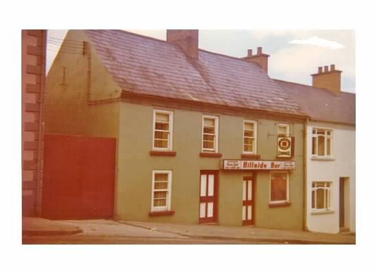
Around the corner from Brockagh was the actual townland Joe was from, Cloghan, with its great views out to the Bluestack mountains (mountains for another time!)  Cloghan has a little pub called The Rambler’s Inn and it is owned by my granddad’s cousin, Connie McGlynn and his wife Brid.  My mum told me before I left “If you are able to call into Connie’s, you should!”  I pulled over and walked in.  

This is where Joe brought me mostly as a boy, I played here with some other children my age and called the pub ‘Connie’s Hotel’.   As I walked in, I noticed ‘McGlynn’s Bar’ on the pub mirror above the fireplace and immediately felt at home!

A woman was working behind the bar, and she turned out to be Brid.  I (re)introduced myself to Brid and we got chatting.  What I hadn’t realised was that this pub used to be a hotel, ‘the Brockagh Hotel’ owned by the McGlinchey’s.  A pub/hotel had been on this site since the early 1800s and was bought by Connie and Brid around St Patrick’s Day 31 years ago, so they’ve had it for about as long as I’ve been around!  I asked Brid if I could photograph the bar and she was of course very accommodating.

So I got to photograph a pub after all.  Oh, and with the rain now lashing down, I’m glad I wasn’t up on my own on One Man’s Pass!

I grabbed some lunch in Ballybofey and headed back over the border from Lifford into Strabane and hit the main roads back to some home comforts.

My two days in Donegal might not have been quite what I had planned, but they were still brilliant!  

I had a fantastic two days though two low points spring to mind

  1. Realising in a snowy Dungannon that I had left my phone in Lisburn, and
  2. The zip of my mountain jacket smacking against my frozen face with the gales on Errigal!

The high points where probably the views out to Altan Lough when the clouds broke, my pint and burger in the hotel on the 1st night after freezing out at Bunbeg, Liverpool winning 3-0, and sitting by the fire at the end in The Rambler's Inn.  When things go wrong, it's not always for the worst!

Saturday 03.12.16
Posted by Stephen Wallace
Comments: 5
 

11 Hours in Fermanagh - A Photo Challenge

Devenish Island at sunrise

The stunning lakelands of Fermanagh were my home until I was 6 years old.  Despite this, and the fact that over the last few years I have taken hundreds of photos of Irish landscapes, I hadn't taken a single photo in Fermanagh.  It was a source of embarrassment in some ways.  How could I neglect one of our most beautiful counties, especially one where I have fond childhood memories?

I decided to change that this summer.  I booked an overnight stay in Enniskillen and kept my fingers crossed that the weather would make the booking worthwhile. I arrived at 8pm and needed to leave by 7am the next morning.  My challenge was that I had 11 hours to capture the essence of Fermanagh (5 hours when you take off 6 hours sleep!).  This blog covers my journey and the photos produced working through in chronological order.

The Janus Figure

The Janus figure, Caldragh cemetery.

My journey to Fermanagh took me through Omagh and Kesh to my first stop, Boa Island. The plan was to start at the north east end of Lower Lough Erne and work down the east side until darkness fell. 

Boa Island is the largest island in Lough Erne and located on the island are two strange carved stone statues in Caldragh cemetery.  The statue pictured above is called the Janus figure and has two faces.  It is thought to represent a Celtic deity and perhaps was made by early Christians who included older pagan beliefs in their grave sites.

As you can see, visitors often leave coins at the statue.  They also make a wish, and hope the statue will provide good luck.

The Jetty to Hare Island

Summer skies over the old jetty to Hare Island

My sunset plans were set for an area of the mainland that looks out to Boa Island.  So, in the time up to sunset and after I had photographed the Janus figure I examined my map and found a jetty that looks out to Hare Island.  Cows grazed on the small Hare Island, seen on the left. I'm sure taking them back and forth by boat is fun!

Portinode

Portinode pier

The unique feature of a county filled with lakes is that you have no shortage of piers to photograph!  This was another unplanned shot in the run-up to sunset (which was shaping up nicely to my right).  Situated in the townland of Portinode, this old pier looks out to the large Boa Island.  I just had to be careful not to sink under the lake with the rest of the pier when getting this shot!  You can see how the pier is sinking at the bottom of the shot.

Boa Island

Sunset over Kesh Forest and Boa Island

Sunset had arrived and I was in my planned location.  On the left was Boa Island and in the distance Kesh Forest which where the sun was due to set behind.  The light was very kind, and that was without making a wish at the Janus figure!  A couple of piers and a boat, interestingly called 'The Alien' provided foreground interest.

Lakeland Sunset

Sunset over Lough Erne and Kesh Forest

As previously mentioned, I had booked this overnight trip two weeks in advance.  Anyone who lives in this part of the world will know for most of this summer we've had grey, cloudy weather and heavy rain.  To fluke a sky like this was such a great feeling and I could tell it would be one of those summer sunsets that keeps on giving long after sunset and into twilight which would give me time to tick off a few more locations.  

This shot was taken about 5 minutes after the sun had sun set behind the tree-line of Kesh Forest in north Fermanagh.  It was so peaceful and if you look on the right of the shot you can see a lone swan bathing in the glowing orange waters.

Muckross

Muckross Jetty, Kesh

It was time to start working southwards along the eastern shores of Lower Lough Neagh towards my bed for the night in Enniskillen.  However, I would still have time for another couple of shots.  I pulled in to Muckross which is a popular boating and fishing destination near Kesh.  I remember caravanning near here in Loaneden when I was younger.  I quickly chose my spot, set up the tripod, clicked my remote and was about to head back to the car when I bumped into a woman photographing the sunset on her phone.  We got chatting about the great sky that night and I explained how I had travelled down from Lisburn for the night to photograph Fermanagh and she suggested I take a trip to Clareview viewing point.  She said how it had a great view right over the lake and also over the small islands dotted around Castle Archdale.

Clareview Twilight

Clareview, half an hour after sunset

I found the small road that leads up to Clareview and could tell I'd been given good advice.  The views down to my left over White Island and the other small islands were so good I almost pulled over there and then.  However, it's a narrow road and I was told there was a viewing point so I kept going until I found the parking bay with stunning views south west over Lower lough Erne.  In the middle distance you can see Castle Archdale Islands Forest and White Island, both forested.  In the far distance you can see the Cliffs of Magho drop sharply into the Lough and Lough Navar Forest.   The sheep clearly enjoyed the view too as they stared towards the red glows of twilight.

Half-time!

Although I could've continued shooting landscapes through the night, I had plans for sunrise and also a lot to do when I got home the next day and didn't want to be a useless zombie all day!  I checked into my hotel, grabbed a quick pint in Saddler's pub and reviewed my photos so far.  After that, I headed for a few hours sleep with the alarm set for 5am.

Devenish Island

Devenish Island at sunrise

The Devenish Island Monastic site was founded in the 6th century by Saint Molaise.  During its history it has been raided by Vikings, burned down and then flourished as a parish church site.  The round tower which is so prominent on the island dates from the 12th century. 
The sun was due to rise behind me and in my head I had imagined a misty lake with the early light of the sun against the round tower.  However, it was one of those special mornings where I got a bit of everything.
The colour was so strong in the eastern sky that it even reached into the western skies behind Devenish.  The lake was perfectly calm with super reflections and there was a gentle touch of mist on the surface of the water. It was time to move on again!

Trory

Peaceful lough at Trory

I didn't move too far to get my next photo.  This was shortly after sunrise further north along the lough at Trory.  I was about to photograph the T-shaped stone jetty when these two swans started to swim towards me and into frame.  I adjusted composition and their reflections and brief poses were much appreciated!

Enniskillen reflections

My next couple of photos took me across Lough Erne to its western side and on crossing the lough I passed through the beautiful island town of Enniskillen (Ceithlenn's island).  I got myself down to the shoreline of the River Erne and looked across to Enniskillen Castle.  It was built almost 600 years ago by the ruling Gaelic Maguires.  Guarding one of the few passes into Ulster from the southwest it has been strategically important throughout its history.

Sillees river valley mist

Early morning mist

From Enniskillen I headed west and on the lower slopes of Belmore mountain, near Boho I spotted this vast area of mist across the landscape.  The colour of sunrise was still strong in the sky against the dew soaked green fields.  I wasn't aware at the time but the area of mist was over the Sillees river, Ross Lough and Carran Lough outside Derrygonnelly.

pollnagollum waterfall

Pollnagollum waterfall at the entrance to Pollnagollum cave

My final destination before heading home was Belmore Forest and Pollnagollum cave.  Pollnagollum comes from the Irish 'Poll na gColm', meaning 'hole of the doves' and is a cave making up part of the extensive Marble Arch Caves.  The waterfall which guards the entrance to the cave has a unique and distinctive flow down from the limestone cliffs above.  The cave is actually a location in the HBO series Game of Thrones.  It was used as Beric Dondarrion's hideout during series 3.

Time up

By the time I had photographed the waterfall it was 7am and I had to be on my way home and onto the M1 motorway.  

My 11 hour photo challenge of the famously lovely county of Fermanagh was complete.

You can view my Fermanagh gallery here.


Saturday 08.15.15
Posted by Stephen Wallace
Comments: 4
 

Tory Island - A Royal Welcome

The sun-kissed cliffs of Tory Island, shortly after sunrise.

Earlier this year, I visited Rathlin Island just off the north coast of Antrim.  I absolutely loved it and you can read the blog here.

At the end of June, I turned 30 and when my wife asked me if there was anywhere in particular I'd like to go, I immediately said Tory Island.  Thankfully Julie was willing to join me and enjoyed it too! Maybe we could make visiting an Irish island an annual tradition....though her reading this will be the first she's heard of this idea.... (if she reads my blogs!)

Tory Island, 9 miles north off the coast of County Donegal, has long been on my wish-list for two main reasons
1) The stunning northern cliffs battered by the Atlantic ocean all year round; and
2) To meet the King!

The King?! Yes, Tory has its own King. King Patsy Dan Rodgers.  Patsy Dan was the popular choice to become the latest in a long line of 'Kings' of Tory.  Whilst Patsy has no formal powers, he ensures everyone is given a warm Cead Mile Failte as they arrive on the island.  Patsy is also a painter, musician, storyteller, fisherman and guide.  
Patsy often welcomes passengers from the ferry that leaves the stunning Magheraroarty beach at the foot of the Derryveagh mountains on mainland Donegal.  However, on the day we made the choppy crossing across Tory Sound, Julie and I were the only two passengers.  We had no royal welcome...he wasn't expecting us.  However, Patsy didn't let us down.  He found us within the hour as we got lunch in the hotel and gave us such a warm welcome.  Patsy is a world-renowned artist and as such was pleased to hear I was to photograph the island that he loves so much.  However, I got the impression Patsy was more photographed than the famous cliffs, and here he is! A real character and gentleman.

Patsai Dan Mac Ruaidhri - an accordion virtuoso!

This blog is a mixture of history, trip review, painfully early sunrise shots, midnight hikes and snapshots.  As with my Rathlin blog, I've tried to cover the landscapes, the pub and the church along with anything else I found interesting along the way.

The island is only 3 miles long and half a mile wide.  One of my favourite aspects of the island was how you could see both sides of the island, north and south, at any one time.  When, you arrive from Magheraroarty you are faced with two immediate views.  The first is a welcome in Irish 'Failte go Oileán Thoraí', as Tory is a genuinely Irish-speaking island and the second is the Tau cross and the remains of a 6th century Monastery bell tower.

Welcome to Tory Island, Donegal!

The Tau Cross and in the background, the remains of the Monastery bell tower.

The monastery was founded by Colmcille and dominated island life and the island skyline until 1595 when it was plundered and destroyed by English troops.  The bell tower is all that remains.

The Tau cross is one of only two in all of Ireland (the other being in Kilnaboy, Co.Clare).  It is believed to date from the 12th century and is one of the oldest representations of a Christian cross.  Island fishermen would often pray in front of the cross before heading out to sea.

Going further back, and into Irish mythology, Balor of the Evil Eye, a giant cyclops made Tory his home and Tor Mor, a precipitous rock at the end of narrow cliffs his fortress.  In fact, these rocky tors are one of the main reasons I visited the island for photography.  'An Eochair Mhor', meaning 'the big key' is a stunning, long, steep-sided spur that juts from the east side of the island into the Atlantic.  The rocky pinnacles along the spur are named 'Balor's soldiers'.  They give the spur the key-like appearance.  The large pinnacle at the end is 'Tor Mor', Balor's fortress. 

An Eochair Mhor, viewed at sunrise.

Alarm set for 4am, I hiked the length of the island from our hotel to the upper reaches of the eastern part of the island to be met with this stunning view. How this is not one of Ireland's most well-known natural landscapes is beyond me.  Afterwards it was a gentle stroll back for an hour's nap and a full Irish breakfast! (More on the excellent hospitality later!)

The whole northern stretch of the island is stunning from start to finish, a photographer and walker's paradise.  Close by to where the picture of An Eochair Mhor was taken is a rock called the Wishing Stone.  It is from this viewpoint the whole island can be seen.  I climbed here on each of the nights we stayed to try and capture a sunset.  On the last night, and at the last minute when I believed it just wasn't to be the sun popped out (and you can see that photo at the end) but up until then a combination of storm clouds and sea mist dominated the sky.  However, I began to feel that these cool blue tones convey the personality of Tory better than a sky of oranges and reds.  I'll leave that up to you.

Last light over Tory island, viewed from the Wishing stone.

After this photo, I began to walk along the cliffs and shortly before midnight made it to Tory's highest point, Morard ('big height').  This was the view over West Town from the summit under nightfall.

Morard, Tory's highest point.

Morard, Tory's highest point.

I continued my midnight hike and from the slopes of Morard there are great views of the western part of the island, with the distant lighthouse clearly in view and the distinctive shape of this rock, called Mearnaid.

Midnight at Mearnaid Rock.

The next morning, Julie and I went West from our hotel and explored West Town and the western cliffs.  The whole island is a joy to walk with little to no traffic and when a car does drive past, a friendly wave is usually on offer.  This was the view from the other side of Mearnaid rock by day, with a small fishing boat on the rarely calm seas.

Mearnaid Rock by day. Mainland Donegal can be seen in the far distance.

The lighthouse is also on the westerly part of the island. It was built in 1832 and is seen below.

Tory Island Lighthouse.

Tory Island has become a bit of an artist's retreat, with its own gallery, the Dixon gallery.  In the 1950s, the famous English painter Derek Hill set up a painting hut near the lighthouse (I don't know why I didn't photograph it!)  Derek started and then mentored the artists' community, teaching local fishermen (and indeed I believe King Patsy Dan) how to paint the dramatic landscapes around them, such as the view out to Balor's Fort, below.

Balor's Fort

Balor's Fort

It's hard to walk 20ft without seeing something new of interest along Tory's northern cliffs.  There's even a large cave but I thought that was best photographed from sea level by someone with a boat! 

Tory twin sea stacks

Tory Island is accepted to be by far Ireland's most remote inhabited island.  The population of just over 100 largely permanent hardy souls is split over four 'towns' An Baile Thoir' (East Town), 'An Baile Thiar' (West Town), An Lár (Middletown) and Úrbaile (Newtown). 

An Baile Thiar (West Town)

What interested and impressed me about Tory was how the vast majority of residents lived there all year round, in contrast to some other Irish islands.  Making a living is hard on an island with a lack of fertile land.  Historically, Tory's bogs were used to help produce poteen and the islanders made a good living from exporting poteen to the mainland, benefitting from being far from the gaze of the authorities.  However, now all that remains of these bogs are stony fields.  Fishing and tourism is therefore of great importance to the island.

An Baile Thior (East Town) with the Derryveagh mountains of Donegal in the distance.

On one afternoon when I was walking up the northern cliffs I noticed a game of football happening and was impressed at how there were enough kids to get a proper game going.  It seems an idyllic upbringing, but perhaps that's easy for a football-obsessed visitor to say.

Tory football match

Old Tory cottage

I said earlier I'd mention the hospitality.  We stayed at Óstán Radharc na Céibhe, also known as the Tory Harbour View Hotel.  Its owners Sean, Patricia, Shauna and Damien gave us a great welcome.  The rooms were clean, the location perfect and the food was superb (I recommend the homemade chocolate brownie cake!)  After our hikes it was bliss to come back to the hotel bar for a pint of Guinness and then simply walk next door for a big steak dinner.  If any of the owners are reading this, then thanks from Julie and I, we will be back!  The full Irish breakfasts brought me back to the land of the living after some early sunrise starts!

Our hotel, viewed from the pier.

As many of you will know, I'm a big fan of my old pubs.  Now, the hotel was only built in 1994 and Club Sóisialta was closed when we were on the island so there were no real historical pubs on the island but I loved the character of the hotel bar regardless.  King Patsy Dan was often found on his stool up at the bar and locals came in and out freely for a quick chat.

The bar, with the King's stool on the far right.

Next door to the hotel is Naomh Colmcille, the island's chapel.  I visited the interior of the chapel for a photo when the rain was lashing down.  A welcome retreat and a lovely colourful church to photograph.

The chapel was built in 1857 and in fact the stained glass windows were presented by artist Derek Hill to thank the islanders for their generosity and kindness during his time there.

Naomh Colmcille.

This kindness and generosity came across to us on our visit and in King Patsy Dan the island has a truly great ambassador and asset.  I would see Patsy daily and he would ask me if I'd captured sunset from the Wishing Stone as he knew I hiked up each night.  I'd keep telling him that the sea mist just wouldn't shift.  It disappointed him.  He really wanted the weather to clear as he maybe thought I would go him disappointed without my shot (not the case!).  He's exceptionally proud of the place he calls home and fought to help islanders stay after a hurricane in the 1970s.  

The night before I left, the weather again was bad with a constant drizzle and greyness in the sky.  I almost didn't head out from the hotel, but you just never know what way the sky will change.
I hiked up to the eastern cliffs and set up my tripod. I waited and watched the sky.  The view was fantastic as it was, despite the sky.  The white-washed houses of An Baile Thiar were clear and the light was flashing at the western lighthouse in the distance.

Then, the horizon started to clear...and just a minute before sunset, that elusive sun popped up and lit the horizon red.  I had got my sunset shot.

I just didn't get to tell Patsy before I left! 

Tuesday 07.21.15
Posted by Stephen Wallace
Comments: 4
 

Rathlin Island - My Kind of Place

East Lighthouse, with the sun rising over the Mull of Kintyre in Scotland.

I have always been fascinated by the islands we have dotted around our coast.  My wife finds it hard to understand that for my 30th birthday in June I'd love a visit to Tory island 9 miles off the north coast of Donegal, rather than somewhere more exotic.  It is unusual then, that it has taken me so long to visit our most well known island, Rathlin.  This was fixed last weekend. I loved it!

Rathlin, from the Irish Reachlainn (the genetitive form of Reachra, meaning 'place of many shipwrecks') has a certain feeling of remoteness attached to it.  It is separated by only 6 miles of water but the waters of Rathlin Sound are treacherous due to the tides of the Irish and North Seas meeting and creating dangerous currents.  During winter, islanders can go many days being completely cut off from the mainland.

Another beautiful morning on Rathlin Island.

I arrived on Rathlin on a Saturday morning and stayed for two nights.  Whilst I knew my afternoons would be spent in the island's only pub watching the final weekend of the Six Nations on the Saturday and Liverpool v Man Utd on the Sunday, I knew I would be spending a lot of time walking and photographing what is a beautiful island.  I was having a bit of trouble thinking of the best way to structure this blog but have decided that I will divide the island into parts, show the photos I got in each area of the island and scatter any history or information along the way.  

Rathlin is an L-shape so it could be argued by some that it doesn't really have a north, east, west and south, but I'm about to pretend otherwise!

Following on from these landscape shots, I'll also have a section each on the pub, the churches and the wildlife.  I really hope you enjoy the photos and find the history interesting.

All of the images in this blog are available in many formats from my Rathlin Island gallery at http://www.hibernialandscapes.com/rathlin-island/  For any queries, please email hibernialandscapes@gmail.com

church bay

Church Bay, shown in the photograph above is the location of the harbour, ferry terminal and most of the island's facilities.  The island is surrounded on most sides by high cliffs (both limestone and basalt) and a safe landing place was historically rare.  The bay is named after the first church on the island, St Thomas's.  A church was located here as early as 580 A.D and indeed Rathlin is Ireland's first inhabited island, believed to have been inhabited from as long ago as 7,000 B.C.

We stayed in Church Bay with Alan and Hilary of Arkell House and from the moment we arrived they made it clear nothing would be too much trouble.  The views here are stunning, such as this one from our bedroom window!

Church Bay. The view from breakfast and from our bedroom!

A 19th century British visitor to the island found that Rathlin had an unusual form of government where they elected a judge who sat on a "throne of turf".  It was during this time that Rathlin's population peaked at 1800.  However, two thirds of the island left the island from this very harbour during the Irish Famine and the population has not recovered since.  At present, the island's population is approximately 125 (though this varies during the year and swells considerably during the summer months with visitors and islanders who live elsewhere during winter.

Boats in Church Bay at sunset.

Rathlin has been the site of a number of massacres. On an expedition in 1557 Sir Henry Sidney devastated the island. In July 1575 the Earl of Essex sent Francis Drake and John Norreys to confront Scottish refugees on the island, and in the ensuing massacre hundreds of men, women and children of Clan MacDonnell were killed. 

Mill Bay

Just around the corner from Church Bay is Mill Bay.  A colony of seals live here and you can often see them bathing on the beach or bathing in the clear waters.  This area is popular with children because of the many rock pools.

The Manor House

This large Georgian house which dominates Rathlin’s harbour was built in the 1870s for the Gage family, who bought the island in 1746 from Lord Antrim for £1,750. 

The last member of the family to live at the Manor House was Brigadier Rex Gage, CBE, MC, who died in 1973. It lay derelict for a while before it was taken over by the National Trust and then re-opened in 1998 as a 12-room hotel.  It is currently undergoing further refurbishment and hopes to reopen next year.

Reflections of Rathlin's cottages and the village pub, McCuaig's.

When you arrive on Rathlin, a prominent part of the shoreline just south of Church Bay is this large and interesting old building. This was the 'kelp store'.  Until the 1930s, when artificial methods replaced it, kelp was a rich source of iodine and soda for glass and soap manufacture and the islanders made an income by gathering it. Kelp production ended in Rathlin in 1938 – 25 years after the Antrim mainland.  The information board nearby explains that the kelp store then became a dance hall until eventually abandoned.

The kelp store

 Below is a shot I took on the walk back from sunset on the island's northern cliffs.  The sunset was strong and whilst the streetlights were on and the island was getting dark there was still great colour in the sky.

Dusk descends on Church Bay

the east of the island

The East Lighthouse perched on Altacorry Head.

I set my alarm for 5.30am on Sunday morning and made the three mile walk from my warm bed to a windy and cold Altacarry Head.  What a great decision!  The views were stunning.  Along the walk I could see early morning oranges and reds around Fairhead and Torr Head on the Northern Irish mainland.  As the road wound round I could clearly see the Mull of Kintyre in Scotland, and this amazing sunrise developing before me.  If you look closely in the above photo you can see the Mull of Kintyre with the sun rising just over it.  

The East Lighthouse was built in 1856 and has been guiding ships through this important stretch of water for almost two centuries.   When I moved closer to the cliff-edge I could start to see the Scottish islands of Islay and Jura to my left and I began to realise just how close to Scotland Rathlin is.  In fact, from the 5th to the 8th century Rathlin Island was the centre of the ancient kingdom of Dalriada which stretched up from County Antrim through the Scottish islands.

It was this connection to Scotland that meant that it was in a cave just underneath this lighthouse where Robert The Bruce took refuge after being defeated in 1306 during his fight against the English for the crown of Scotland. The cave is now called Bruce's Cave but can only be reached by boat.
During his lonely exile it is said that he watched a spider patiently trying again and again to spin a web across an impossible gap and eventually succeed. Inspired, he returned to Scotland, to win victory at the Battle of Bannockburn in 1314. 

It was during my walk around the island after this photo I realised just how quiet the island was at this time of year.  I was walking for hours and I didn't see a single car.  In fact the photo below is by far the busiest I saw the island, with one car waiting at one side of the road for a quad (and the driver's dog) to pass by! Bliss!

Rush hour

The north of the island

Altachuille Bay at sunset

I didn't expect this.  I was told the northern cliffs were impressive but not this.  The Cliffs of Moher are world famous.  These don't seem to have an official name! They certainly don't have one on my detailed OSNI Map anyway.  I guess it's the remoteness.  The Cliffs of Moher have a visitor centre and a constant stream of tour buses but these cliffs are a 1.5 mile hike across open heather and grassland from the nearest road (after you've got to the island by boat!)

I do know that the bay is called Altachuille Bay and there is an old coastguard lookout nearby that was used during the war.  From this spot again, Kintyre, Jura, Islay are visible, as is Inishowen in North Donegal.  What a beautiful place. And the sunset wasn't half bad!  I was in a  great mood by this point.  I got my sunset and now I had a walk back down in the dusk to the harbour for chill con carne and Guinness!

the west of the island

I said before that some people my argue that you can't really get distinct north, east, south and west out of an L-shaped island and they're probably right.  In my definition, the 'west' of the island is everything west of Church Bay but not as far north as Ballyconagan and Altachuille Bay.  The 'west' takes in the townlands of Knockans, Ballygill, Kinramer (where the main wooded area is, on an island of mostly grasses and heather and not many trees) as well as the Kebble nature reserve.

It is in the west of the island where these dramatic cliffs and sea stacks are.  This is home to a huge colony of puffins along with the many other species of birdlife Rathlin has to offer including razorbills, guillemots and kittiwakes.   

Stacknavarlea, viewed from the West Lighhouse.

The view above is taken from the West Lighthouse which is the only lighthouse in the world with the light located at the bottom of the building.  It is also one of only a few lighthouses in the world that flash red instead of white.

This is also the location of the RSPB Seabird Centre which is currently undergoing renovations.

Kebble Lough

Kebble Lough, guarded by a 'friendly bull' lies just east of the cliffs and as we left a sharp rain shower came in behind us to disrupt our sunny walk! Thankfully I managed to capture the rain coming in just before it soaked my camera.

Indeed, as we continued to walk we were again bathed in sunshine and watched the rain move over Fairhead, Rue Point and Torr Head instead.  We were happy with how quickly it moved on.

Fairhead rain

Fairhead rain

There's no reminder (other than daffodils I guess…) quite like lambs to remind you that spring has arrived.  As we walked back along Rathlin's longest road from Kebble to Church Bay we passed through the townland of Ballygill and found these lambs enjoying the weather.

Springtime in Ballygill

the south of the island

The final area of the island I want to talk about is the south.  This is the area south of Church Bay and Mill Bay.  Rathlin has no less than three lighthouses which probably demonstrates the difficulty of the surrounding waters.  We have the East and the West lighthouses and so you'd probably expect this one to be called the South Lighthouse, but you'd be wrong! This is Rue Lighthouse, at Rue Point.  You can see the Causeway Coast in the distance.  It's definitely the island's least aesthetically pleasing of the three lighthouses, but the surrounding area is no less stunning.  The south part of the island is dotted with lakes, cliffs and small beaches.

Rue Lighthouse

We made our way to Rue Point not by road, but along the excellent way marked Roonivoolin walk which brought us along the stunning cliff-line of Roonivoolin.  Views in all directions were fantastic, but in the photo below you can see the view back to the other side of Rathlin.  This view shows off the mix of limestone and basalt in the cliffline, with black on top of white.

Roonivoolin Cliffs

Just to the east of Rue Point is Ushet Point.  Here, an old granary can be found just across the Sea of Moyle from Fairhead.  Ushet Point is one of the only other safe landing points on the island other than Church Bay.

The old granary at Ushet Point.

The old granary at Ushet Point.

On our walk back to Church Bay (sadly, to watch Liverpool lose to Manchester United….) we walked past Ushet Lough.  It was surrounded by many Irish hares running around (just a wee bit too quickly for this landscape photographer!)  I did manage to get one shot which you can see in the wildlife section below.

Ushet Lough

The Pub

As many of you will know, I also enjoy pub photography.  When I arrived on Rathlin the pub was the first place I went, to watch Ireland win the Six Nations (again!)  Before everyone gathered at kick-off I grabbed an opportunity to photograph the pub empty.

McCuaig's opened in 1985 in Church Bay.  It is the island's only pub and an important meeting place for islanders and visitors alike.  Since 1st March it has been under new management and I must say I found the staff and regulars very friendly, with one of the islanders inviting us to his home to watch the football to make up for the lack of Sky tv in the pub!  I wish the new management all the best.

McCuaig's Bar

Before the pub opened in Church Bay, a pub of the same name operated out of the front room of a Mr McCuaig, where the youth hostel is now.  The new pub is decorated with much of the memorabilia from that pub.  I think I'd have enjoyed to have photographed that old pub!  People I spoke to were unsure how long the old McCuaig's was in operation but I would imagine it was a fairly casual affair!

McCuaig's lounge bar

religion on the island

Rathlin has one post office, one pub, one chip shop, one grocery shop and one school.  But it's still part of Northern Ireland, so of course it has two churches! One Protestant and one Catholic.  Both are modest but beautiful with interesting histories.

St Thomas's Church

As the church of the establishment for centuries, the Church of Ireland's church of St Thomas's had the pick of locations and chose wisely, perched under some cliffs near the harbour and gives Church Bay its name.  A church has been on this site since approximately 580 A.D.  It was burned to the ground during the Vikings' first raid on ireland in the 8th century.  The current church was built in 1812.

The interior of St Thomas's Church.

The Catholic Church of the Immaculate Conception is located slightly further up a steep hill next to the island's only school and was built a few decades after the most recent incarnation of the Protestant Church.  During Penal times mass was celebrated under the shade of an overhanging rock in Ballynagard in the centre of the island.  

Church of the Immaculate Conception interior

However, in 1816 the Catholic church purchased the site of an old mill and using stone quarried from the south of the island built the current church in 1865.

wildlife on the island

Rathlin Island as I mentioned before is well-known for its seals, puffins, oystercatchers, hares and other birdlife.  I managed to capture a few of these on my walks.

A seal bathes in Church Bay

On my first evening I came across a large group of seals.  At first I accidentally scared them but they settled again and allowed me to get this shot.

On my walk back from Rue Point, I kept coming across this Irish hare. He was so fast near Ushet Lough but eventually I caught him sitting still on a hill over Doon Bay.

In terms of puffins, I visited too early as the colony returns in April/May.  However, it's a good excuse for a return trip!

In fact, puffins or not, I will be returning to Rathlin Island.  I can honestly say it was one of the most enjoyable trips anywhere in the world that I've been.  The people were friendly, the landscapes beautiful and the weather, (in this case) very kind!  It was peaceful and remote, the island was full of interesting characters and they served a good Ulster Fry and a pint.  

Rathlin is most definitely my kind of place.

Me at the East lighthouse.

Me at the East lighthouse.

Wednesday 03.25.15
Posted by Stephen Wallace
Comments: 14
 

Slievenacloy

From the slopes of Slievenacloy at sunset overlooking Stoneyford Reservoir and Lough Neagh.

I write this blog after a bit of deliberation.  Slievenacloy is a nature reserve only a few miles north of Lisburn, and mere minutes from my home.  In fact, it is Lisburn's only nature reserve.  I've only recently discovered it, despite arrogantly believing that I know most of Northern Ireland.  I've made 5 visits and have seen a grand total of 2 people and 3 dogs during those visits.  Subconsciously, I've almost started to think of it as my own open mountain….Don't get me wrong, Slievenacloy doesn't have the natural beauty of the Mournes and I don't want you to think it does and be disappointed, but it's amazing to have such natural, open space across mountains steeped in history all to yourself, and it's on my doorstep.  I don't want to spoil the secret! But here goes...

I'd first seen/heard of Slievenacloy a few years ago as I cycled past and dismissed it as 'just nice fields to walk through'.  Then when I noticed Slievenacloy in one of the excellent publications produced by the Belfast Hills Partnership alongside the more familiar Divis & Black mountain and Cave Hill, I began to take notice.

View of Divis mountain from Slievenacloy

Slievenacloy is a townland north of Lisburn and comes from the Irish 'Sliabh na Cloiche', meaning mountain of stones.  The reserve, found just off the wonderfully named Flowbog Rd, takes in Boomer's Hill (historically Mullaghglass meaning 'green summit') and Priest's Hill (historically Gormon's Mountain), the highest point in the reserve, at 1,000ft.  

It is believed that this was an important and sacred landscape during the Neolithic and Bronze Ages for prehistoric burial activity, with cairns set in prominent positions on ridges and hill tops. In total, eight prehistoric burial monuments and associated features have been recorded as having once stood on Priest's HIll and neighbouring Collin mountain. Today only a few remains can been seen, including the large Sibs Stone.

Sibs Stone measures 8 and a half feet long, 5 feet high and 6 feet broad in one end. It is raised some inches above the surface by a few small stones on which it is underneath supported.  Local tradition (it would seem giants were the answer to everything here!) says that a giant cast this stone from the seashore to its present berth.

It is also thought that there is money deposited beneath it! Holes where people have explored for this money are still visible.  I've not bothered looking myself. Yet.

View over the eastern slopes.

The area was once inhabited by hardy farmers and there are the remains of five farmhouses in the reserve.  Four of these are basically gone with only some stones left, but the largest cottage, Kernaghan's Farmhouse acts as the start point for all of the trails (which you can find on the Walk NI website).  Bring boots. It's mucky and boggy!)

All of my visits have been during the winter months, when the landscape is barren, bleak and heavy underfoot, but no less beautiful for it.  However, it is claimed the best time to visit the reserve is in summer when it comes alive with the colour of orchids and many other flowers.  I'm no botanist so I can't go into any more detail than that!  I'm looking forward to photographing the reserve in full colour in summer.

Birdwatchers would also love this place.  Again, I don't know much but I know there is plenty of birdlife about and it's not of the normal crow or magpie variety!  I've read that breeding curlew, snipe, lapwing, skylark, grasshopper warbler, reed bunting and meadow pipit can be seen, as well as barn owls.  Irish hares are common in the sheltered valley of the Stoneyford river, seen below (minus the hares I'm afraid!).

Stoneyford valley between Priest's Hill and Mullaghglass, looking over to Collin on a cloudy day.

The site, also an Area of Special Scientific Interest, is dominated by species-rich unimproved pasture and heathland, both wet (definitely wet!) and dry. It is this unimproved pasture that the Ulster Wildlife Trust fought so hard to preserve as previously the land was inaccessible to the public and not being preserved correctly.  
Many old hedgerows and banks remain, and as well as Sibs stone mentioned above, there are several features of archaeological interest, with the mysterious earth ring below high on the list.

Slievenacloy Earth Ring

Normally, such raised banks are clear ringforts or raths, but in this case, the earth ring is not circular enough to be an Early Christian rath, in fact it's almost rectangular. There are suggestions that it may have been a 17th century artillery fort but as there is no evidence for any of these claims, it remains a mystery.

There are fantastic views to be had all round the reserve.  In the east there are views to Divis and Black mountain as well as to Collin mountain, below.

Collin mountain bathed in evening light.

Also on these eastern slopes, Stormont, Scrabo Tower and lots of landmarks of Belfast can be seen, as well as the outline of Scotland on very clear days.  

On the western slopes there are superb views down to Stoneyford Reservoir, Lough Neagh and across and as far away as the Mourne mountains.  One slight problem with this view are the nets from the Mullaghglass landfill site! 

The Mourne mountains from the slopes of Priest's Hill.

South of the earth ring the landscape falls away to the Stoneyford river which begins its life in the reserve before it heads to the well-known reservoir and then joins with the Glenavy river on its way to Lough Neagh.  

It's a calm little stream and is crossed by a series of small bridges and gives the south-side of the reserve a different look to the more mountainous north.

In 2008, Slievenacloy actually appeared in The Independent newspaper as one of the recommended places to visit under the title 'Secret Britain'. 

Since the end of the Second World War, Britain and Ireland's wildflower meadows have decreased by more than 90 per cent, which is why sites like Slievenacloy are so important.  The Ulster WIldlife Trust and Belfast Hills Partnership have, between them done a fantastic job to open up the area to a public and to promote it as a place to explore.  There is something for everyone with accessible paths and information boards as well as open, boggy mountain.

I'll leave you with a picture from the slopes of Priest's Hill at sunset a few weeks ago.  If you do now want to make a visit to see for yourself, try to make sure it's when I'm not there, so I can continue to think of it as my own private mountain! Much appreciated!

Sunset on Slievenacloy

Thanks for reading and if you have any comments or questions just give me a shout.  My email is hibernialandscapes@gmail.com

Sunday 02.22.15
Posted by Stephen Wallace
Comments: 3
 

Pub History: The Hillside, Hillsborough Co.Down

The Hillside Bar is situated on the steep hill that is Main Street in Hillsborough, Co.Down, just outside Lisburn.  Of course that is where the name of the bar comes from. Nice and simple, it's on the side of a hill!  Indeed the hill often proved very dangerous to early vehicles and there are stories of lorries crashing backwards into the front of the pub and blocking entry for days at a time!  Growing up through school, many of my friends were and still are from Hillsborough, so it is a pub I love to visit, not least because it serves a better selection of beer than most local pubs with regular guest ales and beers from the Hilden Brewery.

Following on from my Old Pubs of Lisburn blog, I am continuing to visit some local pubs with interesting histories and managed to visit two pubs last weekend (Coburns (aka Laganview Arms) in Dromara is to follow shortly).  I had arranged my visit to the Hillside by speaking with Jackie Knowles on Twitter.  Jackie has moved to Northern Ireland from the US and has a very interesting family history with the Hillside.  She now works behind the bar and was incredibly friendly and helpful in organising my visit,
giving me plenty of history and making sure the fires were on!

The pub has been called The Hillside all throughout its history having been established in 1752, making it Hillsborough's oldest pub.  There are drawings of the pub in the 1770s which show it marked as "The Hillside".  

The snug bar, which was part of the original living quarters in the pub.  This fireplace has remained unchanged since the 1750s.

Until 1863 the ownership of the pub is unclear, but it is clear that it was primarily opened to serve to farmers and village men.  Situated on the middle of the hill of Main Street, The Hillside was less traveled by farmers from the Dromara Rd side of Hillsborough who would simply stop at the Plough at the top of Main St. Additionally the local men at the bottom of the hill found the Marquess of Downshire (now known as The Parson's Nose) to be more convenient.

In 1826, the Hillsborough Distillery opened along the river that flowed from what is now Hillsborough Lake down through Culcavy (it became known as the Whiskey river and almost certainly flowed through the glen that gave Hillsborough its original name (Cromlyn - crooked glen) before Lord Hill renamed the village it in the 1600s.)
Following on from the distillery, HIllsborough also had its own brewery which opened around 1856.  It was situated opposite St Malachy's parish church and was said to have similar architecture to the church, it must have been an impressive brewery!

Whiskey from the distillery and stout from the brewery were served in the Hillside.  The current workers at the Hillside explained that there underground tunnels between the distillery and Main St (to where the car park is next to St Malachy's) which transported whiskey for sale in the pub.
The stout from the brewery would've been delivered in barrels and bottled in the back houses in McClune's Court by the pub itself (where the beer garden now is).

The Front bar

In 1863, the ownership of the pub becomes clearer when it was bought by Richard Heenan, who was a shopkeeper before becoming landlord of the Hillside.  It would stay in the Heenan family for almost 100 years and despite being officially called The Hillside, most regulars would simply refer to the pub as 'Heenan's'.

Richard Heenan, the first of a long line of Heenan's to run the Hillside

Richard Heenan, the first of a long line of Heenan's to run the Hillside

When Richard died in 1900, the pub passed to his wife Mary-Jane Heenan, as their first son Jimmy was too young to run the pub. 

Mary-Jane Heenan seen here with her children.  James on the far left took over from his mother after she died.

Mary-Jane Heenan seen here with her children.  James on the far left took over from his mother after she died.

Jimmy Heenan on the left of the photo above took over from his mother Mary-Jane and then passed on the pub to his son James Armstrong Heenan.  James Armstrong Heenan left to live in America in the 1950s, leaving the pub to his sister Hazel.

James Armstrong and Hazel Heenan as children. Both would go on to be owners of the pub.

James Armstrong and Hazel Heenan as children. Both would go on to be owners of the pub.

Hazel and her husband Bert Knowles (current Hillside worker Jackie's grandmother and grandfather!) also then left for America with their children.  When I visited the pub I met their son Gary who was actually born in the pub! Much cooler than being born in a hospital...

The picture below is the pub as it was when Hazel Heenan and her husband sold up in the 1950s to the Reilly's.

The Hillside Bar in the 1950s.  

The Hillside Bar in the 1950s.  

Notice the two doors in the picture above.  The door on the left is now a window.  It was the entrance to the living quarters which contained the fireplace seen in my first picture and all of the upstairs of the bar.

The tradition of only serving stout was to continue long after the Hillsborough brewery closed.  The pub was sponsored by Guinness who would deliver barrels to the back houses where the pub would continue to bottle and cork their own drinks.  Only Guinness and liquour would've been served.

The bar itself.

A well-known regular at the Hillside would've been "old Jimmy Walker" who owned the butcher shop next to the pub.  It is said that he would spend 'all day, every day' in the pub drinking.  Who knows when he served his own customers! 

The Reilly's owned the pub only for a short time before Sam Law purchased it in the late 1950s.  He owned it for a few decades before Mrs Quinn bought it and added new rooms towards the back of the pub.  The Hillside had developed a strong interest in darts from the Heenan's ownership and the expanded back room would help facilitate that interest with the pub team competing against other pubs.

In 1989 Diane and Jimmy shields purchased the pub specifically so that it wouldn't become a brewery-owned pub.  They added the restaurant in 1996.  SInce this time the pub has changed hands quite a few times, with the Carmichael family owning the pub between 2001 and 2006 and is now owned by the Beannchor Group who own the Merchant Hotel and many other pubs in Belfast.

The 'library' part of the bar. This is where I'd often sit myself when visiting the pub.

The Hillside Bar despite being open for almost 300 years has been left relatively unscathed from our turbulent past unlike a lot of the pubs in Lisburn.  It has been a quiet rural pub, but is very popular to this day.  I know they run a popular trad session on Sunday afternoons as my father-in-law would sometimes attend!  I was really pleased to hear the pub is now dog-friendly.  What better than sitting with a pint next to a dog warming itself by the fire?!

The only mention of anything untoward in the pub is a ghost called Gladys, known by the staff and a handful of regulars over generations.  When I say untoward….the scariest thing I've heard is that she might turn on the radio so I wouldn't let it put you off making a visit!

Thanks for reading and as always if you have any interesting history about the pub or stories about regular drinkers then please do give me an email at hibernialandscapes@gmail.com and I can include it in the blog.

Tuesday 01.20.15
Posted by Stephen Wallace
Comments: 10
 
Newer / Older

Powered by Squarespace.